How to Reach Bruges Boat Tour — Directions & Tips (2026)
Find the quickest way to Bruges’ canal cruise landings near Rozenhoedkaai, Dijver, and the Fish Market (Huidenvettersplein). Walks from Brugge Station, De Lijn bus routes, parking, and shore-excursion pointers—plus smart time-savers.
Plan Your CruiseQuick Overview
Main canal landings: Rozenhoedkaai/Dijver, Huidenvettersplein (Fish Market), Wollestraat, Katelijnestraat (near Church of Our Lady), and Groenerei (Meebrug/Peerdenbrug). Fastest hub: Brugge Station — around 18–22 minutes’ walk to Rozenhoedkaai, or 8–10 minutes on a De Lijn city bus to ‘t Zand/Markt plus a short walk.
Best for First-Timers
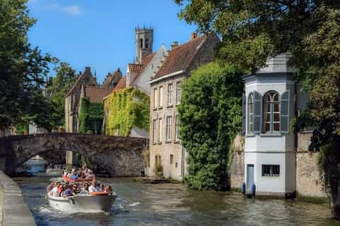
Rozenhoedkaai/Dijver — most photogenic bend; multiple landing stages within a 3–5 minute radius.
Best for Short Walks
Huidenvettersplein (Vismarkt) — central, flat approaches from Markt Square and Burg.
Option 1 — From Brugge Station (Fast & Direct)
Ideal if you arrive by intercity train or bus; clear wayfinding to the historic center.
- Walk: Exit station toward ‘t Zand, continue along Steenstraat to Markt, then 5 min to Rozenhoedkaai/Dijver. Allow 18–22 minutes total.
- Bus: Frequent De Lijn city buses from Brugge Station to ‘t Zand or Markt (≈8–10 min), then walk 5–8 min to landings.
- Taxi: 6–10 minutes to Rozenhoedkaai depending on traffic; drop on the edges of the pedestrian zone.
- Travel time: 15–25 minutes total to most central landings, depending on crowds and lights.
Tip
Use contactless or the De Lijn app for bus tickets. Historic center streets are cobbled—comfortable shoes help.
Option 2 — City Buses to Popular Landings
‘t Zand → Rozenhoedkaai
Get off at ‘t Zand (main hub). Walk Steenstraat → Markt, continue via Breidelstraat to Rozenhoedkaai (10–12 min).
Markt/Belfry → Vismarkt
From the Belfry, stroll 4–5 min to Huidenvettersplein (Fish Market) for central landings.
O.L.V.-Kerk (Church of Our Lady)
For Katelijnestraat landings near the church and Gruuthuse, follow the canal paths (5–7 min from the church).
Groenerei Bridges
For Meebrug/Peerdenbrug photo spots and nearby embarkation, head north from Markt (6–8 min).
Tickets & Passes
Buy single rides on board/contactless, or use the De Lijn app. Buses are frequent between Station ⇄ ‘t Zand/Markt.
Option 3 — Driving, Parking & Bikes
Bruges’ UNESCO center is largely pedestrianized. Driving inside the ring is possible but slow on cobbles; parking on the edge + walking is easiest.
- Best value: Centrum-Station car park by the train station—large capacity, signed footpath into town.
- Central garages: ‘t Zand, Pandreitje, Biekorf—short walks to Markt/landings.
- Bikes: Cycle lanes ring the center; park at signed racks near Dijver/Markt (don’t block quays or bridges).
Accessibility
Quays can have steps and uneven stones. Some landings require stepping down into low boats—ask staff for assistance.
Arriving from Brussels, Ghent, or Zeebrugge
From Brussels
IC trains to Brugge run frequently (≈1 hr). From the station, walk 18–22 min or bus 8–10 min to Markt.
From Ghent
Trains take ≈25–35 min. Same station-to-center approach as above.
From Zeebrugge (Cruise)
Shuttles or trains reach Brugge in ≈20–30 min. From there, bus/walk to the landings; allow 45–60 min pier-to-boat overall.
Luggage?
Boats are compact—store large bags in station lockers or hotel first. Strollers should fold at boarding.
Seasonality
Boats run most days Mar–Oct; winter service is weather-dependent with reduced hours—check the day’s timetable.
Practical Tips
Arrive Early
Queues build 11:00–16:00. Aim for opening or after 16:00. Have e-tickets ready at the kiosk or gangway.
What to Bring
Light layer (breeze on water), compact umbrella, camera/phone strap, and comfortable shoes for cobbles.
Choose the Right Landing
Base it on where you already are: Markt/Burg → Vismarkt; Groeningemuseum → Dijver; Church of Our Lady → Katelijnestraat.
Language & Audio
Skippers usually give live commentary in EN/FR/NL, often adding DE/ES as needed. Keep voices low under bridges.
Getting There Cheatsheet
Closest Landings
Rozenhoedkaai/Dijver • Huidenvettersplein (Vismarkt) • Wollestraat • Katelijnestraat (O.L.V.-Kerk) • Groenerei (Meebrug/Peerdenbrug)
Typical Times
Brugge Station → Rozenhoedkaai: 18–22 min walk • Station → Markt by bus: 8–10 min + 5–8 min walk • Zeebrugge → Brugge: 20–30 min.
Boarding
Scan mobile QR at kiosk/gangway. Lines may split by language/time; stay with your group.
Apps
SNCB/NMBS (trains) • De Lijn (city buses) • Google Maps for walking paths & live stops.
Best Photos
Rozenhoedkaai at golden hour • Meebrug/Peerdenbrug reflections • Begijnhof swans.
Weather Watch
Boats run in light rain; seats are open-air and low—bring a shell. Service may pause in high wind/storms.
Ready to Cruise Bruges’ Canals?
Pick your nearest landing, choose a time that beats the crowds, and book a flexible canal cruise with instant mobile tickets.
Book Bruges Boat Tickets